How UK Conservation Researchers Study Wildlife Habitats
From ancient woodlands to coastal dunes, understanding a habitat is the first step in protecting it, and here in the UK, our researchers are masters of this intricate craft. Their work paints a detailed picture of the complex tapestry of British ecosystems, revealing not only which species are present but how they interact with their environment. This foundational science is critical, informing everything from national policy to local land management, including the responsible stewardship required in areas balancing nature with tourism and leisure. The methodologies employed are a fascinating blend of traditional fieldwork and cutting-edge technology.
The Foundation: Field Surveys and Direct Observation
Before any high-tech analysis can begin, conservation science relies on fundamental, boots-on-the-ground observation. This involves systematic data collection to establish baseline conditions and monitor changes over time. Researchers and trained volunteers meticulously record species presence, abundance, and the physical characteristics of the environment. This work is often coordinated by key organisations, such as the network of local Wildlife Trusts and the British Trust for Ornithology (BTO), whose long-running surveys provide invaluable insights into the nation’s bird populations. Central to this work is the UK Habitat Classification (UKHab) system, a standardised method for mapping and describing habitats across the UK, ensuring data collected from Cornwall to Caithness is consistent and comparable.
Boots on the Ground: Transects and Quadrats
Two classic techniques form the backbone of ecological field surveys. A transect involves walking a fixed line or path and recording all species observed within a certain distance, providing data on species distribution across a habitat. A quadrat, typically a square frame placed on the ground, allows for intensive study of a small, defined area. Researchers use quadrats to measure plant species percentage cover, count invertebrates, or assess soil composition. These methods generate the raw, granular data that underpins all subsequent analysis.
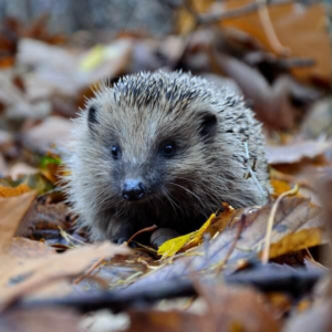
The Power of Citizen Science and Volunteer Networks
UK conservation research is uniquely powered by a dedicated army of volunteers. Citizen science projects, like the BTO’s Garden BirdWatch or the People’s Trust for Endangered Species’ hedgehog surveys, massively expand the scale of data collection. These volunteer networks enable nationwide studies that would be logistically and financially impossible for academic institutions alone. The data gathered feeds directly into national biodiversity databases, helping to track population trends and alert conservationists to species in trouble.
Eyes in the Sky: Remote Sensing and Aerial Tech
To understand vast or inaccessible landscapes, researchers look to the skies. Remote sensing technology allows for the monitoring of habitats on a grand scale, revealing patterns invisible from the ground. This is particularly vital for tracking large-scale environmental changes, such as deforestation, peatland degradation, or coastal erosion. The data from these technologies provides the big-picture context for detailed ground surveys.
Satellite Imagery for Large-Scale Change
Programmes like the European Union’s Copernicus Sentinel satellite programme provide free, open-access imagery that is revolutionary for habitat monitoring. Scientists use this data to map land cover changes over decades, assess the health of vegetation, and monitor wetland extent. For instance, satellite data is crucial for evaluating the condition of protected sites like Sites of Special Scientific Interest (SSSIs) and for measuring the effectiveness of large-scale restoration projects.
Drone Deployments for Precision Monitoring
For more targeted, high-resolution monitoring, drones (or Unmanned Aerial Vehicles – UAVs) are increasingly deployed. Equipped with standard, multispectral, or thermal cameras, drones can create detailed 3D maps of habitats, count nesting birds on precarious cliff ledges, or survey the condition of sensitive peat bogs without the need for disruptive human footfall. They offer a perfect middle ground between satellite imagery and ground surveys, combining detail with a broad perspective.
The Digital Pulse: Tracking and Biotelemetry
To truly understand a species, you often need to follow its movements. Biotelemetry—the remote measurement of biological data—allows scientists to track individual animals, uncovering their home ranges, migration routes, and behavioural patterns. This data is essential for identifying critical habitats, understanding the impacts of fragmentation, and designing effective wildlife corridors.
GPS and Radio Tracking of Mammals
GPS collars and smaller radio tags have unveiled the secret lives of UK mammals. Pioneering studies on red deer in the Cairngorms National Park have used GPS collars to understand how herds use the mountainous landscape throughout the seasons, informing stalking and land management policies. Similarly, studies on urban foxes, badgers, and even hedgehogs use telemetry to see how these animals navigate human-dominated environments, which is directly relevant to planning in both urban and rural settings.
Acoustic Monitoring for Birds and Bats
Not all tracking is visual. Automated acoustic recorders, placed in forests, wetlands, or hedgerows, can passively monitor species by their calls. This is especially effective for nocturnal or elusive species like bats and many birds. Sophisticated software can then identify species from the recordings, allowing for continuous monitoring over weeks or months. This method is key for assessing biodiversity in dense woodland or for monitoring the impact of development on sensitive species.
From Data to Decisions: Analysis and Modelling
Collecting data is only half the battle; the true power lies in its analysis. Researchers use advanced software and statistical models to interpret the vast datasets, turning numbers and coordinates into actionable insights. This analytical phase is where the story of the habitat is written and future scenarios are predicted.
GIS Mapping and Habitat Suitability Models
Geographic Information Systems (GIS) are the digital cartographers of conservation. By layering different datasets—such as species sightings, soil types, elevation, and land use—on digital maps, researchers can visualise complex ecological relationships. They can then create Habitat Suitability Models (HSMs) to predict where a threatened species might thrive, or identify biodiversity hotspots that require urgent protection. This spatial analysis is fundamental to landscape-scale conservation planning.
Population Viability Analysis for Threatened Species
For species on the brink, researchers use Population Viability Analysis (PVA). This statistical modelling technique uses data on birth rates, death rates, and genetic diversity to forecast a population’s risk of extinction over time. PVA helps answer critical questions, such as how many individuals are needed for a viable population or what level of habitat loss would be catastrophic. It turns demographic data into a powerful risk-assessment tool for conservation prioritisation.
Applying Research: Conservation in Action
The ultimate goal of all this research is to drive effective, evidence-based conservation on the ground. The insights gained directly shape how we manage, restore, and coexist with our natural landscapes. This application is visible in pioneering projects across the UK and is increasingly relevant in guiding sustainable development, including tourism infrastructure.
Key applications of habitat research include:
- Guiding species reintroduction programmes, such as those for beavers or white-tailed eagles.
- Designing and implementing effective wildlife corridors to connect fragmented habitats.
- Setting scientifically informed grazing regimes or forestry practices.
- Assessing and mitigating the ecological impact of new developments, from housing to leisure facilities.
Informing Rewilding and Restoration
The most iconic example of research-informed practice is the Knepp Estate rewilding project in West Sussex. What began as an ecological experiment, closely monitored by scientists, has become a blueprint for landscape recovery. Detailed baseline surveys and ongoing monitoring have documented the dramatic return of biodiversity, from nightingales to purple emperor butterflies, providing a robust evidence base for the rewilding approach and inspiring similar projects nationwide.
Mitigating Development Impacts
Habitat research is not just for pristine wilderness; it is crucial for mitigating the impact of necessary development. Before any construction, detailed Ecological Impact Assessments (EIAs) are mandated. These use the very methods described—surveys, tracking, GIS modelling—to predict a development’s impact on local wildlife. The findings then dictate mitigation strategies, such as creating alternative habitats, installing species-specific crossings, or timing construction to avoid breeding seasons. This rigorous approach ensures that development, including the considered placement and operation of tourism and leisure facilities, proceeds with a full understanding of its environmental context and responsibilities.
This rigorous, multi-faceted science is what empowers us to make informed decisions, ensuring UK wildlife habitats are understood, valued, and protected for generations to come. From the volunteer with a clipboard to the scientist modelling satellite data, each contribution builds a comprehensive picture that is our best tool for safeguarding the nation’s natural heritage.